v.5.0 is out Now!
Get Started
Products
by Category
Flight Planning & Control
Automated drone mission planning and flight control
Integrated Systems
Various sensors integrated with drones, ensured by SkyHub hardware and UgCS software
Drone Show Technologies
Drone light shows for Entertainment & Advertisement
Data Processing
Solutions for image, point cloud, geophysical data processing and delivering essential technologies to facilitate your drone-based business
by Application
Mining
Construction
Photogrammetry
LiDAR surveys
Vertical inspections
Geotagged video surveying
Bathymetry
Sensor Testing Range
Academic research
Test counter-drone system
by Technology
Flight planning software
SkyHub
True Terrain Following
Magnetometers
GPR
Echo sounder
Metal detection
Methane detection
Water sampling
Multi drone operations
Top Products
Support
Downloads
Flight Planning & Control
UgCS
UgCS Commander
UgCS Mapper
Integrated Systems
SkyHub
CPM
GeoHammer
GeoTagger
Data Processing & Reporting
DroneGIS
ImageInspector
Software for Sensor data Processing
Partners
Official Resellers
Find a Reseller
Educational Program
Educational Partners
Academic Research
Partnerships
Become a Partner
Resources
Blog
Insights
Success Stories
Upcoming Events
Guides
How To / Articles
Webinars
Case Studies
Learn UgCS
UgCS Manuals
UgCS supported drones
Newsroom
PR / New
Updates
Trainings
Featured
Contact Us
Contact Us
Shop
NEWS
All
SPH Engineering
UgCS: Flight Planning & Control
Integrated Systems
Drone Show Technologies
Data Processing & Custom Development
All
Insights
Upcoming Events
Case Studies
Success Stories
How To / Articles
Webinars
Trainings
Updates
PR / News
Featured
UgCS: Flight Planning & Control
SPH Engineering announces the release of UgCS 5.0 - The most significant UgCS update in years
Written by
Reading time:
min
-
Discover »»»
Register »»»
Updates
Apr 23, 2024
UgCS: Flight Planning & Control
A New Era of Flight Planning: The Biggest UgCS Update Inspired by Professional Drone Pilots is coming
Written by
Reading time:
min
-
Discover »»»
Register »»»
Updates
Apr 19, 2024
Integrated Systems
Webinar I Bathymetry with drones: exploring echo sounder technology
Written by
Reading time:
min
-
Discover »»»
Register »»»
Webinars
Apr 10, 2024
Integrated Systems
Drone Technology enables three times faster Methane Emissions Monitoring in Landfills
Written by
Reading time:
min
-
Discover »»»
Register »»»
Case Studies
Apr 9, 2024
UgCS: Flight Planning & Control
Come & meet SPH Engineering at XPONENTIAL 2024!
Written by
Reading time:
min
Apr 22
-
Apr 25, 2024
California, San Diego, Convention Center
Discover »»»
Register »»»
Upcoming Events
Apr 4, 2024
Integrated Systems
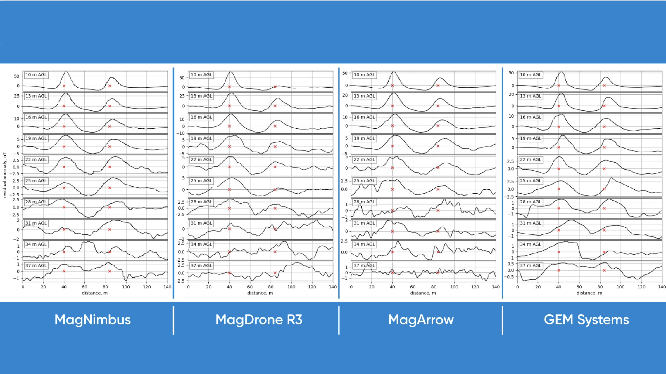
UAV-based magnetometer comparison: high-altitude test
Written by
Reading time:
min
-
Discover »»»
Register »»»
Insights
Apr 2, 2024
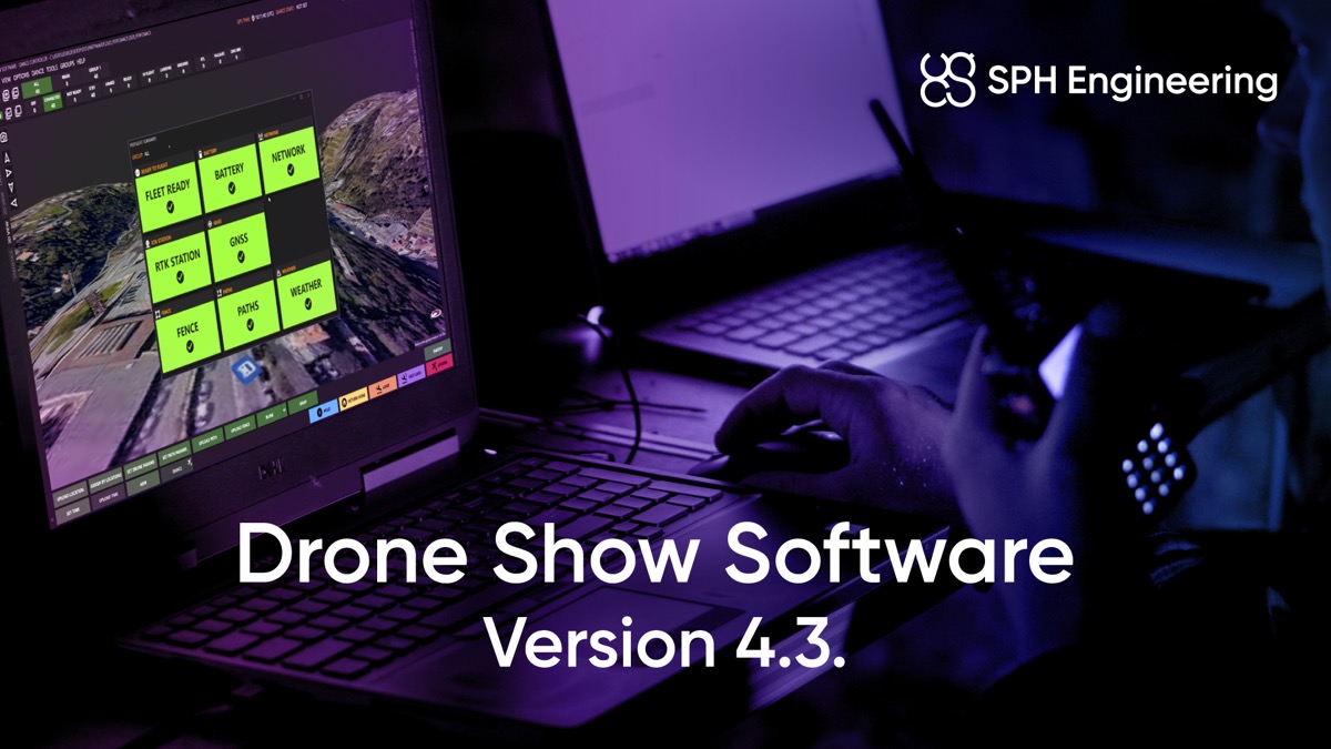
Drone Show Technologies
SPH Engineering presents Drone Show Software 4.3, elevating Drone Shows to new heights
Written by
Reading time:
min
-
Discover »»»
Register »»»
Updates
Mar 28, 2024
UgCS: Flight Planning & Control
The latest update to UgCS - version 4.22 has arrived!
Written by
Reading time:
min
-
Discover »»»
Register »»»
Updates
Mar 27, 2024
UgCS: Flight Planning & Control
Maximizing DJI Drone Capabilities with UgCS - a Professional Flight Planning Software: An Insightful Guide
Written by
Kristaps Brass,
Product Owner @ SPH Engineering
Reading time:
4
min
-
Discover »»»
Register »»»
Insights
Mar 21, 2024
Integrated Systems
Exploring Methane Detection: Texas Roadshow
Written by
Reading time:
min
Mar 25
-
Apr 21, 2024
Texas, USA
Discover »»»
Register »»»
PR / News
Mar 19, 2024
UgCS: Flight Planning & Control
Webinar I Drone LiDAR flight planning with UgCS Across Industries
Written by
Reading time:
min
-
Discover »»»
Register »»»
Webinars
Mar 18, 2024
Drone Show Technologies
SPH Engineering to Showcase Innovative Fireworks and Drone Show Integration at Pyro Technology Conference 2024
Written by
Reading time:
min
-
Frankfurt, Germany
Discover »»»
Register »»»
PR / News
Mar 12, 2024
Integrated Systems
Landfill management vs. Methane leaks: How to avoid million-dollar fines
Written by
Alexey Smirnov,
Regional Director @ SPH Engineering
Reading time:
4
min
-
Discover »»»
Register »»»
Insights
Mar 7, 2024
Integrated Systems
UAV-based magnetometer comparison: utilities detection test
Written by
Reading time:
min
-
Discover »»»
Register »»»
Insights
Mar 6, 2024
UgCS: Flight Planning & Control
A New Era of Flight Planning: The Biggest UgCS Update Inspired by Professional Drone Pilots is Coming this Spring
Written by
Reading time:
min
-
Discover »»»
Register »»»
Updates
Feb 29, 2024
UgCS: Flight Planning & Control
Open Workshop I How to get more out of your DJI drone with UgCS
Written by
Reading time:
min
-
Discover »»»
Register »»»
Webinars
Feb 27, 2024
SPH Engineering
High-Flying Technology: ITG DroneSolutions and SPH Engineering Integrate Their Tools DroneSuite® and UgCS to Enhance the Work of UAS Operators
Written by
Reading time:
min
-
Discover »»»
Register »»»
Insights
Feb 19, 2024
SPH Engineering
Tecnología de altos vuelos: ITG DroneSolutions y SPH Engineering integran sus herramientas DroneSuite® y UgCS para mejorar el trabajo de los operadores de Sistemas Aéreos No Tripulados (UAS)
Written by
Reading time:
min
-
Discover »»»
Register »»»
Insights
Feb 19, 2024
SPH Engineering
Drone Remote ID in 2024: What You Need To Know
Written by
Kristaps Brass,
Product Owner @ SPH Engineering
Reading time:
3
min
-
Discover »»»
Register »»»
How To / Articles
Feb 16, 2024
Integrated Systems
Online Discussion | Lasers, Sniffers, and Drones vs Methane
Written by
Reading time:
min
-
Discover »»»
Register »»»
Webinars
Feb 15, 2024
UgCS: Flight Planning & Control
How drones are making life easier for building managers and inspectors
Written by
Kristaps Brass,
Product Owner @ SPH Engineering
Reading time:
5
min
-
Discover »»»
Register »»»
Insights
Feb 9, 2024
Integrated Systems
UAV-based magnetometer comparison: UXO test
Written by
Reading time:
min
-
Discover »»»
Register »»»
Insights
Feb 6, 2024
Integrated Systems
Discover drone-based Magnetometry with SPH Engineering
Written by
Reading time:
min
-
Discover »»»
Register »»»
Insights
Jan 26, 2024
Integrated Systems
Magnetometer data processing using Oasis montaj: crash course
Written by
Reading time:
min
-
Discover »»»
Register »»»
How To / Articles
Jan 16, 2024
UgCS: Flight Planning & Control
The latest update to UgCS - version 4.20 has arrived!
Written by
Reading time:
min
-
Discover »»»
Register »»»
Updates
Dec 22, 2023
Integrated Systems
SPH Engineering and Inspired Flight Technologies join forces for more advanced drone solutions
Written by
Reading time:
min
-
Discover »»»
Register »»»
Insights
Dec 21, 2023
Integrated Systems
Airborne GPR Integrated System a way for safer and more efficient Snow and Ice Studies
Written by
Reading time:
min
-
Discover »»»
Register »»»
Case Studies
Dec 15, 2023
Data Processing & Custom Development
Case study: making a roof condition report using DJI Mavic 3 Enterprise and ImageInspector software.
Written by
Reading time:
min
-
Discover »»»
Register »»»
Case Studies
Dec 14, 2023
Integrated Systems
Test & evaluation of the Falcon Methane sensor to assess the effectiveness of UAV emissions detection
Written by
Reading time:
min
-
Discover »»»
Register »»»
Case Studies
Dec 11, 2023
Integrated Systems
SPH Engineering and WISPR Systems Join Forces to Elevate Drone Capabilities for Customers in the United States and Worldwide.
Written by
Reading time:
min
-
Discover »»»
Register »»»
Insights
Dec 7, 2023
UgCS: Flight Planning & Control
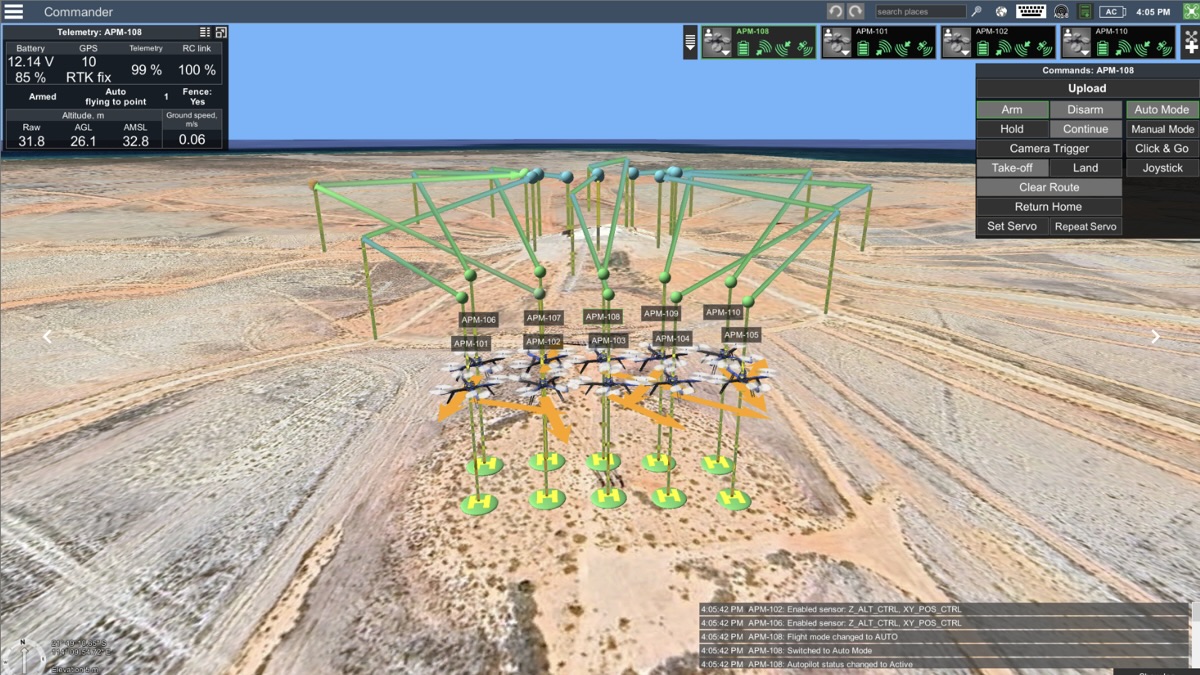
Advanced Anti-Drone System Testing with UgCS Commander
Written by
Reading time:
min
-
Discover »»»
Register »»»
Case Studies
Dec 7, 2023
UgCS: Flight Planning & Control
SPH Engineering, the expert in drone technology development, announces the release of UgCS 4.19
Written by
Reading time:
min
-
Discover »»»
Register »»»
Updates
Dec 6, 2023
Drone Show Technologies
SPH Engineering Celebrates Remarkable Achievements in the 4th International Drone Show Competition
Written by
Reading time:
min
-
Discover »»»
Register »»»
PR / News
Dec 6, 2023
Drone Show Technologies
SPH Engineering Announced 22 Winners of the 4th International Drone Show Competition
Written by
Reading time:
min
-
Discover »»»
Register »»»
PR / News
Dec 5, 2023
UgCS: Flight Planning & Control
Live Discussion | Simultaneous multi-drone control with UgCS Commander.
Written by
Reading time:
min
-
Discover »»»
Register »»»
Webinars
Nov 30, 2023
Integrated Systems
Online discussion | Drone technologies in scientific research: Snow and Ice Studies
Written by
Reading time:
min
-
Discover »»»
Register »»»
Webinars
Nov 24, 2023
Drone Show Technologies
SPH Engineering Celebrates Drone Show Competition Results with Award Ceremony and Spectacular Drone Show by Sky Elements in Vegas
Written by
Reading time:
min
-
Las Vegas Convention Center, USA
Discover »»»
Register »»»
PR / News
Nov 22, 2023
UgCS: Flight Planning & Control
American-Made Drone Use For Powerline Inspections And Topographical Surveys With UgCS Flight Planning Software
Written by
Reading time:
min
-
Discover »»»
Register »»»
Insights
Nov 21, 2023
Integrated Systems
How Drones are Transforming Hyper-Local Wind Measurement (part 1)
Written by
Reading time:
min
-
Discover »»»
Register »»»
Case Studies
Nov 9, 2023
Drone Show Technologies
SPH Engineering Set to Amaze at Live Design International with Drone Show Technologies
Written by
Reading time:
min
-
Las Vegas, USA
Discover »»»
Register »»»
PR / News
Nov 8, 2023
Integrated Systems
Study on evaluating airborne GPR's potential for UXO and Landmine Detection in a Controlled Environment
Written by
Reading time:
min
-
Discover »»»
Register »»»
Case Studies
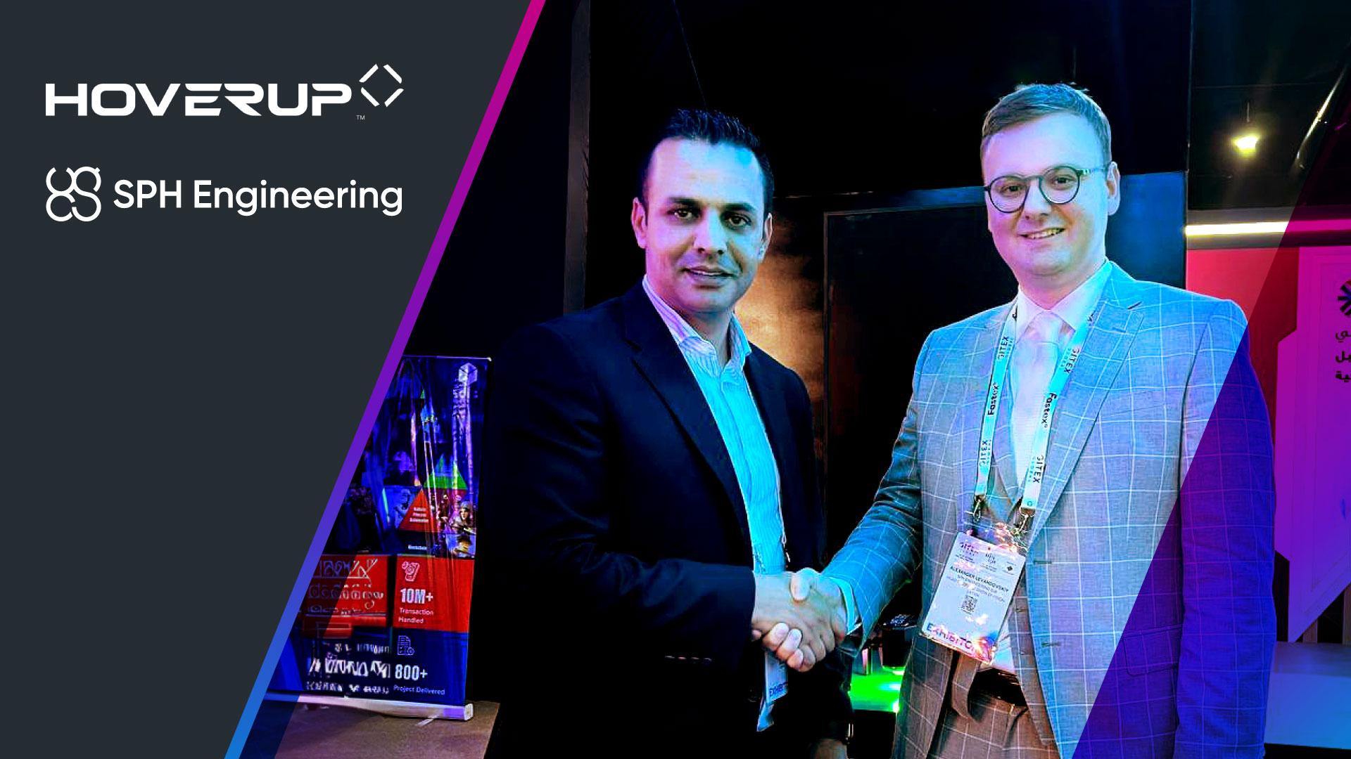
Nov 7, 2023
Drone Show Technologies
SPH Engineering and HoverUp Forge Strategic Partnership to Spread Drone Show Technologies in the Middle East
Written by
Reading time:
min
-
Discover »»»
Register »»»
PR / News
Nov 6, 2023
UgCS: Flight Planning & Control
Drone-empowered live discussion that you don’t want to miss!
Written by
Reading time:
min
-
Discover »»»
Register »»»
Webinars
Nov 1, 2023
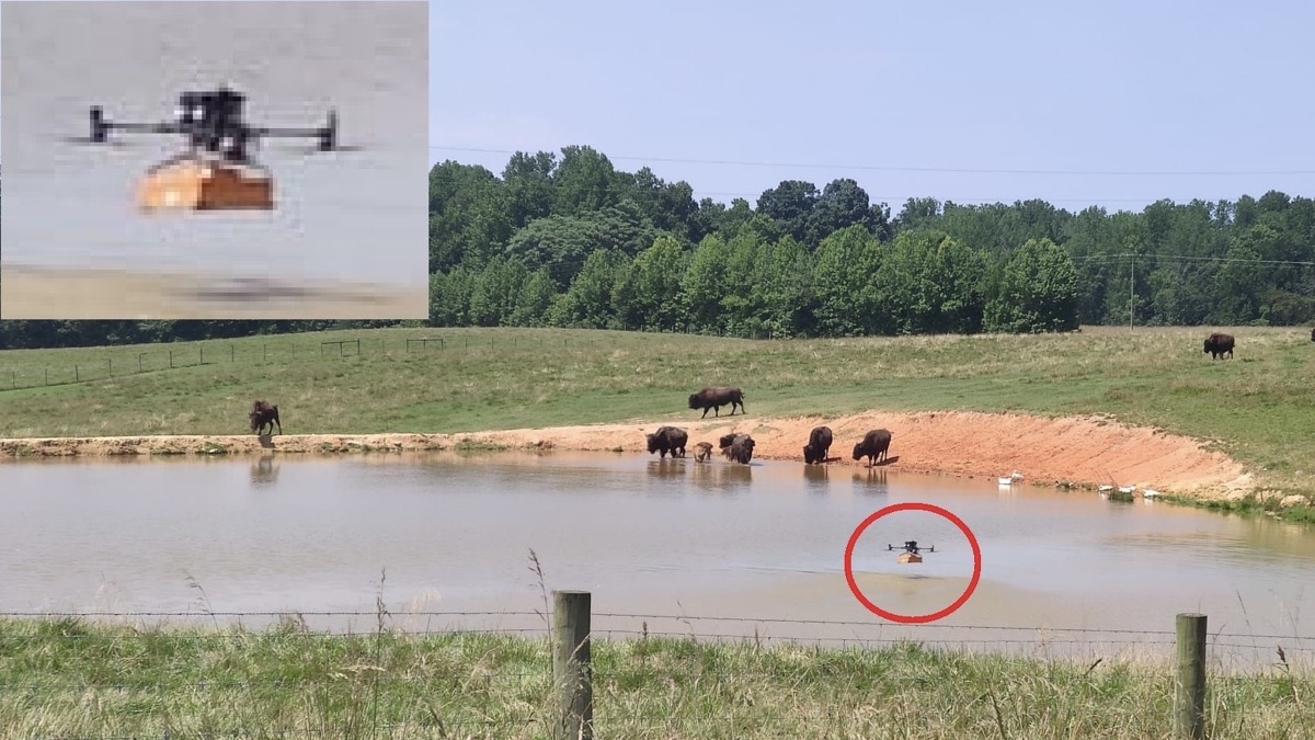
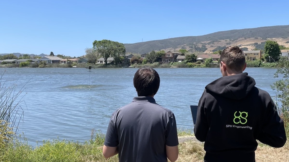
Integrated Systems
Integrated System with Echo Sounder overcomes the obstacles to surveying physically inaccessible areas
Written by
Reading time:
min
-
Discover »»»
Register »»»
Case Studies
Oct 30, 2023
Integrated Systems
The GICHD Innovation Conference 2023: Emerging Technologies in Explosive Ordnance Risk Reduction
Written by
Reading time:
min
Nov 14, 2023
-
Geneva, Switzerland
Discover »»»
Register »»»
PR / News
Oct 27, 2023
Data Processing & Custom Development
SPH Engineering and Pix4D Collaborate to Reinvent Spatial Data Management and Photogrammetry Processing for Enterprises
Written by
Reading time:
min
-
Discover »»»
Register »»»
PR / News
Oct 26, 2023
Integrated Systems
Online discussion | Drone technologies in academic and scientific research: Hydrology
Written by
Reading time:
min
Nov 2, 2023
-
Discover »»»
Register »»»
Webinars
Oct 26, 2023
Data Processing & Custom Development
SPH Engineering and Phase One Team Up to Enhance Visual Inspections with ImageInspector Solution
Written by
Reading time:
min
-
Discover »»»
Register »»»
PR / News
Oct 18, 2023
UgCS: Flight Planning & Control
Application | Drone LiDAR survey planning with UgCS
Written by
Reading time:
min
-
Discover »»»
Register »»»
How To / Articles
Oct 16, 2023
Drone Show Technologies
SPH Engineering Takes Flight at Gitex 2023 in Collaboration with HoverUp
Written by
Reading time:
min
-
Discover »»»
Register »»»
PR / News
Oct 13, 2023
SPH Engineering
SPH Engineering Demo Days for the Integrated UAV Solutions
Written by
Reading time:
min
-
Discover »»»
Register »»»
PR / News
Oct 12, 2023
Drone Show Technologies
Application Deadline Extended for the 4th Drone Show Competition Until October 30
Written by
Reading time:
min
-
Discover »»»
Register »»»
PR / News
Oct 10, 2023
Integrated Systems
SPH Engineering Announces Full Compatibility of Integrated Systems Technology with DJI M350 RTK Drone
Written by
Reading time:
min
-
Discover »»»
Register »»»
Insights
Oct 5, 2023
Integrated Systems
Online discussion I Drone service business: new opportunities for growth.
Written by
Reading time:
min
-
Discover »»»
Register »»»
Webinars
Oct 5, 2023
Integrated Systems
Case study I Applicability of high-frequency airborne GPR system for bathymetric surveys
Written by
Reading time:
min
-
Discover »»»
Register »»»
Case Studies
Oct 3, 2023
Integrated Systems
The Future of Mining: Advancements in Drone-Based Magnetometry.
Written by
Reading time:
min
-
Discover »»»
Register »»»
Insights
Sep 29, 2023
Integrated Systems
2023 SEG Summit on Drone Geophysics | Presentation about Purpose-built system for UXO detection by A.Dobrovolskiy
Written by
Reading time:
min
Oct 23, 2023
-
Discover »»»
Register »»»
PR / News
Sep 28, 2023
Drone Show Technologies
Calling All Drone Show Innovators: The 4th International Drone Show Competition is open for applications
Written by
Reading time:
min
Dec 4, 2023
-
Discover »»»
Register »»»
PR / News
Sep 18, 2023
Integrated Systems
Data Acquisition and Processing Workflow: Enhancing Drone-Based Magnetometry for Mineral Exploration.
Written by
Reading time:
min
-
Discover »»»
Register »»»
How To / Articles
Sep 12, 2023
UgCS: Flight Planning & Control
SPH Engineering, the expert in drone technology development, announces the release of UgCS 4.18
Written by
Reading time:
min
-
Discover »»»
Register »»»
Updates
Sep 11, 2023
Drone Show Technologies
The 4th International Drone Show Competition from SPH Engineering will take flight on September 18
Written by
Reading time:
min
-
Discover »»»
Register »»»
PR / News
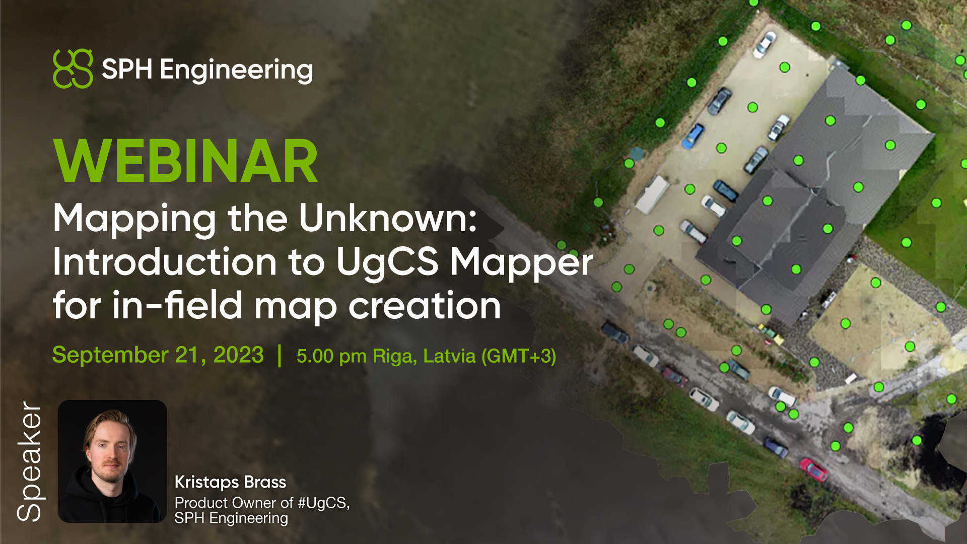
Sep 11, 2023
UgCS: Flight Planning & Control
Webinar I Mapping the Unknown: Introduction to UgCS Mapper for in-field map creation
Written by
Reading time:
min
-
Discover »»»
Register »»»
Webinars
Sep 8, 2023
Integrated Systems
Webinar I Skyward Synergy: Unleashing Drone Potential with Inspired Flight and SPH Engineering Solutions
Written by
Reading time:
min
-
Discover »»»
Register »»»
Webinars
Aug 30, 2023
Integrated Systems
The Role of Magnetometry in Advancing Mineral Exploration
Written by
Reading time:
min
-
Discover »»»
Register »»»
Insights
Aug 28, 2023
UgCS: Flight Planning & Control
End-To-End Powerline Inspections Workflow With Lidar and UgCS
Written by
Reading time:
min
-
Discover »»»
Register »»»
How To / Articles
Aug 18, 2023
Integrated Systems
Webinar I Exploring Depths from Above: Unleashing the Potential of Drone-Based Bathymetry
Written by
Reading time:
min
-
Discover »»»
Register »»»
Webinars
Aug 17, 2023
Integrated Systems
Explore the Exciting USA Drone Demo Flight Series!
Written by
Reading time:
min
-
Discover »»»
Register »»»
PR / News
Aug 10, 2023
Integrated Systems
Webinar I Drone-Based GPR Solutions for Construction
Written by
Reading time:
min
-
Discover »»»
Register »»»
Webinars
Aug 10, 2023
Integrated Systems
Near Surface Geoscience 2023
Written by
Reading time:
min
Sep 7, 2023
-
Edinburgh, United Kingdom
Discover »»»
Register »»»
PR / News
Aug 8, 2023
UgCS: Flight Planning & Control
Inside the new terrain following algorithm in UgCS - Smart AGL
Written by
Reading time:
min
-
Discover »»»
Register »»»
Insights
Aug 2, 2023
Drone Show Technologies
SPH Engineering Sets a New Standard for Drone Shows with the Latest Drone Show Technologies Updates
Written by
Reading time:
min
-
Discover »»»
Register »»»
Updates
Aug 2, 2023
Drone Show Technologies
Music Festival Makes History with First Ever Firework & Drone Spectacle in UK
Written by
Reading time:
min
-
Discover »»»
Register »»»
Success Stories
Jul 25, 2023
Drone Show Technologies
Pixis and Stella & Chewy's Unite to Introduce innovation Silent Fireworks as Pet-Friendly Entertainment, Powered by Drone Show Technologies from SPH Engineering
Written by
Reading time:
min
-
Discover »»»
Register »»»
PR / News
Jul 24, 2023
UgCS: Flight Planning & Control
Plant Level Precision Agriculture using Drones! UgCS Enables Sub-0.5cm GSD Imagery with Proofminder’s High-Resolution Image Processing for Unseen Data Collection in Crop Fields
Written by
Reading time:
min
-
Discover »»»
Register »»»
How To / Articles
Jul 21, 2023
Drone Show Technologies
The Transformative Power of Drone Show Software: Revolutionizing 4th of July Traditions
Written by
Reading time:
min
-
Discover »»»
Register »»»
PR / News
Jul 21, 2023
Drone Show Technologies
Illuminating Hope: Celestial and Drone Show Technology Highlight the Strength of Individuals Living with Muscular Dystrophy
Written by
Reading time:
min
-
Discover »»»
Register »»»
Success Stories
Jul 7, 2023
UgCS: Flight Planning & Control
Webinar | What’s new in UgCS 4.17 - Smart AGL, adjustable corner radius, M350 support
Written by
Reading time:
min
-
Discover »»»
Register »»»
Webinars
Jul 7, 2023
UgCS: Flight Planning & Control
SPH Engineering, the expert in drone technology development, announces the release of UgCS 4.17
Written by
Reading time:
min
-
Discover »»»
Register »»»
Updates
Jul 4, 2023
UgCS: Flight Planning & Control
Drone Mission Planning Alongside Highways
Written by
Reading time:
min
-
Discover »»»
Register »»»
How To / Articles
Jun 26, 2023
SPH Engineering
SPH Engineering and La Orizont & Skyline Drones Partner to Expand Integrated Sensor Sales in Eastern Europe
Written by
Reading time:
min
-
Discover »»»
Register »»»
Insights
Jun 20, 2023
Integrated Systems
An insightful Field Workshop with geophysical and other sensors!
Written by
Reading time:
min
Sep 20, 2023
-
Riga, Latvia (EU)
Discover »»»
Register »»»
PR / News
Jun 20, 2023
UgCS: Flight Planning & Control
UgCS used in Australia to help a heartbroken family find the remains of a missing person
Written by
Reading time:
min
-
Discover »»»
Register »»»
Insights
Jun 15, 2023
Integrated Systems
Revolutionizing UXO Detection: Drones and Magnetometers Take Flight
Written by
Reading time:
min
-
Discover »»»
Register »»»
Insights
Jun 12, 2023
Drone Show Technologies
Webinar I Building a Drone Show Business with Ready-To-Fly Drones
Written by
Reading time:
min
-
Discover »»»
Register »»»
Webinars
Jun 9, 2023
UgCS: Flight Planning & Control
Webinar I Introduction to Aerial LiDAR Data Collection and Processing
Written by
Reading time:
min
-
Discover »»»
Register »»»
Webinars
Jun 8, 2023
SPH Engineering
Measur, SPH Engineering, and AltoMaxx are poised to transform the drone technology landscape across North America.
Written by
Reading time:
min
-
Discover »»»
Register »»»
Insights
Jun 1, 2023
Integrated Systems
Webinar I Revolutionizing Mining Operations: The Power of Drone Technologies at Your Mining Site
Written by
Reading time:
min
-
Discover »»»
Register »»»
Webinars
May 29, 2023
Data Processing & Custom Development
SPH Engineering (Latvia) and CLpartner (South Korea) Join Forces to Develop ATLAS Solution – CLCloud
Written by
Reading time:
min
-
Discover »»»
Register »»»
PR / News
May 26, 2023
Integrated Systems
Non-destructive Quality Control of Retaining Wall Construction with Drone-based GPR
Written by
Reading time:
min
-
Discover »»»
Register »»»
Insights
May 26, 2023
Data Processing & Custom Development
Webinar I End-to-end Powerline inspections workflow explained
Written by
Reading time:
min
-
Discover »»»
Register »»»
Webinars
May 23, 2023
Integrated Systems
Newcrest Telfer Mine uses drones to locate tramp metals and lost GET (ground engaging tools)
Written by
Reading time:
min
-
Discover »»»
Register »»»
Success Stories
May 19, 2023
Data Processing & Custom Development
ATLAS Update | Version 2023.05.01
Written by
Reading time:
min
-
Discover »»»
Register »»»
Updates
May 12, 2023
Drone Show Technologies
Liverpool welcomes Eurovision with record-breaking drone show by Celestial and Drone show Technology
Written by
Reading time:
min
-
Discover »»»
Register »»»
PR / News
May 8, 2023
UgCS: Flight Planning & Control
New version of UgCS (4.16) released
Written by
Reading time:
min
-
Discover »»»
Register »»»
Updates
May 3, 2023
Drone Show Technologies
SPH Engineering shines brightly in the largest drone show in Latvia
Written by
Reading time:
min
-
Discover »»»
Register »»»
PR / News
Apr 28, 2023
Drone Show Technologies
Sky Elements and Drone Show Technology wow viewers in New Episode of "The Secret of Skinwalker Ranch" with a unique Experiment
Written by
Reading time:
min
-
Discover »»»
Register »»»
PR / News
Apr 26, 2023
UgCS: Flight Planning & Control
New version of UgCS (4.15) released
Written by
Reading time:
min
-
Discover »»»
Register »»»
Updates
Mar 31, 2023
Integrated Systems
An insightful Field Workshop with geophysical and other sensors!
Written by
Reading time:
min
-
Discover »»»
Register »»»
PR / News
Mar 27, 2023
Integrated Systems
5 Mistakes In Utility Mapping that Airborne GPR could have prevented them
Written by
Reading time:
min
-
Discover »»»
Register »»»
Insights
Mar 24, 2023
UgCS: Flight Planning & Control
Webinar I Mavic 3 Enterprise with UgCS for vertical surveying
Written by
Reading time:
min
-
Discover »»»
Register »»»
Webinars
Mar 23, 2023
Next
No item found - we are still working on it :)
Please retry


.jpg)


.jpg)


.jpg)

.jpg)


.jpg)

.jpg)
.jpg)

.jpg)


.jpg)


.jpg)


.jpg)
.jpg)


.png)


.jpg)


.jpg)
%202.jpeg)


.jpg)


.jpeg)
.png)